Evidence for the earliest structural use of wood at least 476,000 years ago
World’s oldest known wooden structure pre-dates our species : Archaeologists have discovered the oldest evidence yet of a wooden structure crafted by the hands of a human ancestor. Two tree trunks, notched like Lincoln Logs, were preserved at the bottom of the Kalambo River in Zambia. If the logs’ estimated 476,000-year-old age is correct, it means that woodworking might predate the emergence of our own species, Homo sapiens, and highlights the intelligence of our hominin ancestors.
The simple structure, made by shaping two logs with sharp stone tools, may have formed part of a walkway or platform for human ancestors who lived along the Kalambo River nearly 500,000 years ago.

Marks on the logs show they were cut, chopped and scraped with an array of stone tools found at the site. One log, a type of bushwillow, overlies the other and is held in place by a large inverted U-shaped notch in its underside.
 In the African context, indirect evidence for woodworking comes from use-wear traces and residues on Early Pleistocene stone tools in East Africa (Oldowan, Acheulean)14,15,16. Actual wood objects are found in Mid-Pleistocene waterlogged deposits in southern Africa with Acheulean and Middle Stone Age tools. At Kalambo Falls, wood was recovered from Acheulean horizons in the 1950s–1960s (sites A and B), but taphonomic processes removed evidence of intentional shaping from most pieces17. A wood chip and three objects with transverse notches raised the possibility of intentional modification. Attempts to date the wood gave minimum ages18,19,20. At Amanzi Springs, South Africa, a single stick with a possible chop mark was reported from waterlogged Acheulean deposits excavated in the 1960s21. The deposits were radiometrically dated (approximately 404–390 kyr), with wood found in recent excavations but without evidence of modification10. The earliest clearly modified wood object, collected in 1952 from spring deposits at Florisbad, South Africa, was associated with Middle Stone Age tools and hominin remains (Homo helmei)22. The object’s tip shows cutmarks and fine striations23, but its location relative to dated deposits is uncertain24.
Excavations at Kalambo Falls in 2019 recovered five modified wood objects at site BLB (Fig. 1b) from four areas (BLB2, BLB3, BLB4 and BLB5) in sediments above and below river level (Fig. 1c). A sixth object, from BLB3, showed no evidence of modification. Two objects were associated with Acheulean artefacts below the river (BLB3 and BLB5); three from contexts above river level, without stone tools (BLB2 and BLB4) (Fig. 2).

a, Site location in south-central Africa. b, Course of the Kalambo River (in outline) from around 1956 to 2006 in relation to previous excavations at sites A, B, C, D and C North. Site BLB (2019) and excavation units BLB1, BLB2, BLB3, BLB4 and BLB5 are located along the current main channel (blue). c, Cross-section of the 2019 excavation units showing the location of 16 luminescence dating samples (KF01–KF17, dark blue circles, uncertainties (±) shown at 1 − σ) by unit. Unit BLB1 is a geological section of the full cliff exposure from ground surface to below water level. The three colour bands indicate clusters of pIR IRSL ages grouped by mean ages and standard error of the mean. The earliest wood objects (BLB5, BLB3) are in the lower green band with a mean age of 476 ± 23 kyr. The blue band has a mean age of 390 ± 25 kyr and incorporates the wood object in BLB2. The overlying yellow band has a mean age of 324 ± 15 kyr and incorporates wood objects in BLB4. Red diamonds indicate modified wood objects. Inset map data in a: Google Maps, Google 2021, INEGI; the map of Kalambo Falls was drawn using Arc-GIS Open Street Map. Map data in b: Google Imagery 2021 CNES/Airbus, Maxar Technologies; the 1960s river course, with site locations, was redrawn from figure 7.2 of ref. 17 with permission from Cambridge Univ. Press.

a, BLB5 structural element (object 1033). b, BLB3 ‘wedge’ (object 660). c, BLB2 ‘digging stick’ (object 219). d, BLB4 cut log. e, BLB4, tapered piece with single chop-mark. Scale bars, 10 cm.
The Quaternary sequence is a 9-m-deep exposure above the Kalambo River (BLB1 is a geological section). Sediments are fluvial sands and gravels with occasional, discontinuous beds of fine sands, silts and clays with wood preserved in the lowermost 2 m (Methods). A permanently elevated water table has preserved wood and plant remains (Supplementary Information Section 1). The depositional sequence is typical of a high- to moderate-energy sandbed river that underwent lateral migration. The sands are dominated by a lower unit of horizontal bedding and an upper unit of planar/trough cross-bedding. Upper and lower sand units are separated by fine sands, silts and clays with plant material deposited in still water after the river migrated/avulsed elsewhere in the floodplain. Wood is deposited in this environment either through anthropogenic emplacement, or naturally transported in the flow, and snagged on sand bedforms (Supplementary Information Section 1).
Dating is based on 16 sand samples collected for luminescence analyses from deposits bracketing key finds including those containing wood. Younger samples are dated using single-grain quartz optically stimulated luminescence (OSL) and older samples by postinfrared infrared stimulated luminescence (pIR IRSL) from potassium-rich feldspars (Methods and Supplementary Information Section 2). The pIR IRSL approach used extensively in recent years25,26 does not suffer the problems that can generate large uncertainties associated with thermally transferred OSL (TT-OSL), as seen at Site C North (Fig. 1b)20. The new ages (Extended Data Table 1) are in stratigraphic order (1σ) (the only exception being KF10 and KF11), forming three clusters based on mean ages (and error of the mean) (Fig. 1c). The earliest cluster (476 ± 23 kyr) incorporates wood in deposits below river level (BLB3, BLB5). The intermediate cluster (390 ± 25 kyr) encompasses one wood tool in BLB2 found above river level. The upper cluster (324 ± 15 kyr) brackets two wood objects in BLB4, above river level. No wood was found higher up the sequence.
The wood was sampled for identification to species level (Methods and Supplementary Information Section 3)27 and for radiocarbon dating, to assess for an intrusive origin; all dates were infinite (more than 50 kyr ago (ka), T. Higham personal communication). Infrared spectroscopy shows partial mineralization of the wood (silica) (Methods and Supplementary Information Section 5). Surface modifications were identified on photographically generated models (Methods). The need to keep the wood wet made standard photography, structured light scanning and microscopy impractical because of high surface reflectance and pooling of water in key features, obstacles overcome by photogrammetry and reflectance transformation imaging (RTI) on the submerged wood. Additional photographs were taken after brief episodes of drying.
Manufacture marks and use history are described using standardized terminology1 with interpretations supported by replication experiments (Methods and Supplementary Information Sections 6 and 7). Functional interpretations are drawn from wood artefacts in waterlogged Holocene sites in Zambia28, the UK29,30 and ethnographic sources (Methods and Supplementary Information Section 8)31,32. Individual pieces are described by excavation block from oldest to youngest.
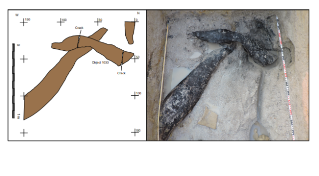
In BLB5, one modified object was recovered from basal sands containing flake tools, cleavers and handaxes. Object 1033 is a log (Combretum zeyheri) 141.3 cm long × 25.6 cm, with tapering ends in three parts, which overlies a larger treetrunk at a 75° angle (Fig. 3a,b). The area of overlap is a U-shaped notch 13.2 cm long by 11.4 cm wide, transverse to the long axis (Fig. 4). The underlying trunk, also modified, and left in situ, passes through the notch (Fig. 3a).

The underlying log passes through a central notch cut into the upper log (object 1033) and extends into the section. Plan view of the unit (left) and during excavation (right). The numbers refer to the distance in centimetres.

From left to right, the location of the central notch in profile, shaping marks in and on the margins of the notch (a–k), the notch in profile from the opposite side. The image on the right shows the upper surface of the log, and the three parts of the log (1–3) separated by cracks. White arrows indicate locations of shaping facets on the sides and upper surface of the log.
Bark (on parts 1 and 2) and a knot (part 1) occur near sapwood on object 1033. The notch (part 1) exposes tangential and radial longitudinal sections, with sapwood missing. Evidence of chopping and scraping occurs on the upper surface of the notch (Fig. 4, areas a–d, and Extended Data Fig. 1) and on the lower surface (Fig. 4, areas e–k, and Extended Data Fig. 1). Area a has two transverse intersecting sets of scraping marks with superimposed parallel linear striations (maximum length 12.5 mm with V-shaped cross-sections, maximum width 3.2 mm). Area b has two linear transverse entry facets (18.8 mm long × 1.6 mm wide). Area c is a single facet with clear entry and stop marks (24 mm long × 1.4 mm wide). Area d is an irregular pit (9.7 mm long × 6.8 mm wide) (Extended Data Fig. 1).
The lower areas e–h are sets of multiple intersecting linear striations with V-shaped cross-sections, transverse to the long axis (maximum length 17.3 mm × 1 mm width) (Extended Data Fig. 1). Area i striations are sinuous, parallel (42.8 mm long) and transverse to the grain with indeterminate cross-sections. A small entry facet cuts area e. Area j is defined by multiple convex-shaping facets (27 mm maximum length × 14 mm width) intersecting the bark surface and forming the flat surface below (Extended Data Fig. 2). All facets have lost definition during storage. Area k (Extended Data Fig. 2) is a single convex facet (41.8 mm × 39.8 mm).
On the left side and upper surface of part 2 (Fig. 4), at least 12 convex-shaping facets and some intercutting are clearly visible on excavation (Extended Data Fig. 3). Five remain visible after storage as dimpling (Extended Data Fig. 3), resembling faceting marks on waterlogged wood from Star Carr, UK29. Consecutive facets define a portion of the upper tapered edge of part 3 (Extended Data Fig. 4). Two clusters of small convex facets occur on the upper surface of part 1 (Fig. 4 and Extended Data Fig. 4).
Surface modification occurs on the underlying trunk at its midpoint and along the narrowed end that passes through and beyond the notch (Fig. 3 and Extended Data Fig. 5). At the midpoint, a small area (approximately 10 cm × 5 cm) preserves multiple short parallel striations transverse to the grain, with V-shaped sections, indicative of scraping1 (Extended Data Fig. 1). The log’s end tapers in plan and profile view with two sets of shaping marks visible. Parallel linear V-shaped cutmarks, transverse to the grain occur at the start of a break in slope, increasing in depth and length downslope (Extended Data Fig. 5). A second set of marks occurs on the flat surface which emerges beyond the notch and continues into the section (Extended Data Fig. 5). Multiple linear and intersecting groups of V-shaped fine striations extend across this surface at acute and right angles to the grain.
We interpret the notch as intentional, made by scraping and adzing1 to create a join between the log and trunk, forming a construction of two connected parts. Infrared spectroscopy (Supplementary Information Section 5) provides indeterminate evidence for use of fire in shaping the notch. Clark17 described a similar find, from the Acheulean in Site B, of comparable length (165 cm long) with a “wide and deepish groove” transverse to the long axis, with tapered ends. He interpreted the groove as anthropogenic and suggested it was part of a structure. The excavation of two interlocking logs in BLB5, with shaped ends on both objects supports this interpretation. We know of no comparable construction in the early archaeological record.
In BLB3, two wood objects were found among plant material beside a large unmodified treetrunk. Flake tools, cleavers, handaxes and core axes occur in this deposit. Object 661 (Ficus spp.) is a V-shaped piece of branch, lenticular in cross-section with no visible shaping marks (not illustrated). Object 660 (Kigelia africana), 36.2 cm long, rounded on one side with outer bark on both surfaces, tapers to an offset point cut 60° across the long axis (Fig. 2b and Extended Data Fig. 6). The base is convex with a deep crack initiated in the pith, extending partially down each side (Extended Data Fig 6). Two modified areas occur below and transverse to the grain: a facet entry heel33 (a) and faint parallel linear striations of indeterminate profile (b) (Extended Data Fig. 6). Above the tip are four sets of marks: two intercutting convex facets with internal linear V-shaped cross-sections (c and d) and two sets of parallel striations (V-shaped) transverse to the grain (e and f) (Extended Data Fig. 6). The tip ends in a blunt break, subsequently rounded, its other side having three faint step fractures transverse to the grain obscured by the pitted surface (Extended Data Fig. 6).
We interpret this as an intentionally shaped object altered by high-impact compression down its long axis. Possible uses include a wedge, an incompletely processed firewood and a portable work base (Methods). Minimally modified bark wedges are known ethnographically31 and short-shaped roundwood wedges from the Mesolithic (Star Carr, UK)30. This unusual object has no parallel in the Middle Pleistocene record.
In BLB2, object 219 (K. africana) was recovered in two refitting parts, one preserved in sediment, the other in the river directly below (Extended Data Fig. 7). The combined length is 62.4 cm, a maximum breadth at the base 11.9 cm, midsection breadth 6.1 cm and 1.3 cm at the offset tip (Fig. 2c). No bark occurs on the object; the upper surface is concave from base to tip (Extended Data Fig. 7). Faint linear striations, with indeterminate cross-sections, cut across the grain near the tip on both sides along with small (less than 10 mm) indistinct convex facets (Extended Data Fig. 7). The obverse surface preserves four areas with linear striations above the tip, including around two knots, with indeterminate cross-sections (Extended Data Fig. 7). Tip rounding may be from exposure to the river or use. Mid-Holocene waterlogged deposits at Gwisho, central Zambia preserved four digging sticks. Only one has small facets (less than 20 mm) on both sides of the tip28. The Gwisho tools are short by comparison with those used historically by Kalahari foragers32 but similar in length to object 219. We interpret object 219 as a digging stick based on its morphology and presence of shaping facets33,34.
In BLB4 two wood objects were preserved in clays, one above the other (Fig. 2d,e). No stone tools were found. The upper object (Combretum zeyheri) is rectangular (59.24 cm × 29.34 cm × 7.7 cm) with bark traces and sapwood exposed on longitudinal surfaces (Extended Data Fig. 8). Evidence of radial cellular compression indicates flattening by sediment overburden. The ends bear distinct chop marks across the long axis (Fig. 2d; Extended Data Fig. 8). The obverse surface has one entry facet parallel to the grain and a set of transverse parallel linear striations of indeterminate profile (Extended Data Fig. 8).
Well-preserved chop marks occur at end a where they descend in four steps, with a V-shaped profile, maximum depth of 2.3 cm, and the top step expanding in width from 13 mm to 25 mm (Extended Data Fig. 8). Stepped cuts occur across end b (Extended Data Fig. 8). The length of cuts and slight curvature suggest a broad, sharp, cleaver-like edge, the depth indicating applied direct force, either handheld or hafted (Methods and Supplementary Information Section 7). We interpret this object as a portion of treetrunk cut to size, indicating capacity to work wood at a large scale.
The lower object (C. zeyheri) (Fig. 2e) is from branch wood, with a side-branch attachment, split centrally, length 37.9 cm, tapering from the base (12.3 cm wide) to a broken tip (2.1 cm wide) (Extended Data Fig. 9 and Supplementary Information Section 4). A single chop mark above the tip is transverse to the grain, V-shaped in profile with an irregular termination. We were unable to interpret this object.
The recovery of modified wood with an exceptional level of preservation at Kalambo Falls places woodworking firmly in the Mid-Pleistocene of Africa. Our understanding of innovation among early hominins has been largely inferred from lithic artefacts35. Wood from tree trunks enabled humans to construct large objects such as platform foundations that necessitated tools for felling and hewing. The large cutting tools of the Acheulean fulfilled these roles in the long co-evolution of stone- and woodworking13,14,15. Hominin use of the Kalambo River basin coincides with an extended period of forest cover (470–274 kyr)36,37. Availability of forest resources and a permanent elevated water table created a habitat conducive to sustained occupation. Life in a periodically wet floodplain would be enhanced by constructing a raised platform, walkway or foundation for dwellings38.
Woodworking was also a precursor for the Mid-Pleistocene invention of hafting, which increased efficiency of basic actions such as chopping and scraping39. The interlocking logs from BLB5 anticipate hafting’s core concept: the combination of two or more parts to make a construction40, enhancing our understanding of the technical cognition of these toolmakers11. Exceptional conditions of preservation give us this glimpse of a capacity to create a built environment by hominins hitherto perceived as mobile foragers with limited technological diversity41.
Related Post
A shocking documentary proves that mermaids do exist
SHOCKING Revelation: Thuya, Mother of Queen Tiye, Was the Grandmother of Akhenaten and Tutankhamun—What Ancient Egyptian Secrets Did She Leave Behind?
Breaking News: Astonishing Discoveries at Karahan Tepe Confirm an Extraterrestrial Civilization is Hiding on Earth, and NO ONE Knows!
Breaking News: Researchers FINALLY Discover U.S. Navy Flight 19 After 75 Years Lost in the Bermuda Triangle!
NASA’s Secret Investigation: Uncovering the Astonishing Mystery of the UFO Crash on the Mountain!
Explosive UFO Docs LEAKED: Startling Proof That Aliens Ruled Ancient Egypt!