Pavlopetri, Greece; a submerged prehistoric town
This post is a summary of information on Pavlopetri, Lakonia, Greece, a submerged prehistoric town.
Off the coast of Laconia in south-eastern Peloponnese, Pavlopetri is a submerged prehistoric town, which consists of intact building foundations, courtyards, streets, graves, and rock-cut tombs.

Pavlopetri became the first underwater city to be fully digitally mapped and recorded in three dimensions, and then brought back to life with computer graphics.
The result shows how much it has in common with port cities of today despite the fact that its heyday was 4,000 years ago.
Pavlopetri appears as a series of large areas of stones indicating building complexes, among which a network of walls can be traced.
It is a city of well-built roads lined by detached and semi-detached two-storey houses. There are larger apparently public buildings and evidence of a complex water management system involving channels and guttering.
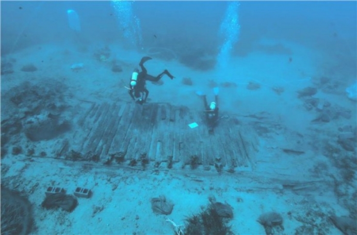
Dotted in between the buildings and sometimes built into the walls themselves there are stone-lined graves. These contrast with an organised cemetery just outside the city.
There is much about Pavlopetri that parallels our own towns and cities, and our own suburban way of life – people living side by side along planned-out streets.
This was not a village of farmers but a stratified society where people had professions.
Pavlopetri offers a unique opportunity to study in detail how an ancient port functioned, how ships came in and, most importantly, the extent of maritime contacts and trade in the Bronze Age.
As a thriving port Pavlopetri was open to a heady mix of influences from the sea. Like modern coastal cities its wealth was built on commerce and trade.
Visiting traders and seafarers ensured that the people of Pavlopetri were in touch with all the latest innovations and were at the cutting edge of current fashions.
Archaeologists have recovered the shards of everyday items such as cooking pots, crockery, jugs, storage vessels and grinding stones as well as finer drinking vessels probably kept to impress and brought out when higher status guests paid a visit or used to make offerings to the gods.
Imported vessels came from all around the Aegean and from Minoan Crete. Equally the people of Pavlopetri copied Cretan and mainland styles producing their own versions out of local pottery.
Scattered all over the seabed at Pavlopetri are the remains of hundreds of large storage vessels known as pithoi.
These could have been easily loaded on and off ships and were used to transport a range of commodities including olive oil, wine, dyes, perfumes and smaller exotica such as figurines or high status table wares.
Dense concentrations of these vessels at particular buildings suggest a form of centralised storage and presumably redistribution was taking place at the site.
Such an operation would have required an advanced level of administration and accounting to keep track of imports and exports.
It would have required written documents and we can assume that in common with the finds of Linear A tablets from Minoan sites and Linear B tablets from Mycenaean sites – the first evidence of writing in Europe – some form of script was known and used at Pavlopetri – although no definite evidence has so far been found.

Pavlopetri was part of the birth of a new type of city in Europe. Not one based around a god-like king or sacred palatial structure, but rather one based on trade and economics.
All of the world’s major modern coastal cities owe their success to their relationship with the sea. All had at their heart a gateway to the sea and the rest of the world. Pavlopetri can perhaps be seen as one of the first links in this chain which continues to this day.
(Source: http://www.bbc.com/news/magazine-15191614)

Abstract Pavlopetri, off the coast of Laconia, Greece, is a submerged prehistoric town, which consists of intact building foundations, courtyards, streets, graves, and rock-cut tombs. New underwater research in 2009 consisted of detailed underwater survey of the structural remains (using a robotic total station and sector-scan sonar technology) alongside sampling of the artefactual material across the site. In addition to the digital recording of the 30,000 m² of previously known buildings, over 9000 m² of new buildings were discovered in 2009 including a large rectangular hall and a street lined with buildings. The ceramics recovered confirm the Mycenaean occupation of the site but also reveal occupation as early as 3500 BC making Pavlopetri, at over 5000 years old, the oldest known submerged town in the world.

Introduction In 2009 the University of Nottingham, through a British School at Athens permit, began a five-year collaborative project with the Ephorate of Underwater Antiquities of the Hellenic Ministry of Culture and Tourism and the Hellenic Centre for Marine Research (H.C.M.R.) to outline the history and development of the submerged prehistoric town at Pavlopetri, which lies just off the Pounta shore, opposite the island of Elaphonisos, in southern Laconia.

Project background Submerged archaeological remains were first identified off the coast of southeastern Laconia in the west end of the Bay of Vatika in 1904 by the geologist Fokion Negris (1904: 362–3) but the importance of his discovery was not widely recognized at the time. The remains were re-discovered in 1967 by Nicholas Flemming who identified and confirmed the existence of a prehistoric town at the location (Flemming 1968a, 1968b). In 1968 a team from the University of Cambridge surveyed the submerged remains over six weeks using a fixed grid system and hand tapes (Harding et al. 1969; Harding 1970). They produced a plan of a prehistoric town covering an area of c. 300 × 100 m, lying in 1–4 m of water. At least 15 separate building complexes (consisting of a series of rooms), courtyards, streets, two chamber tombs, and 37 cist graves were identified. The underwater site was seen to continue southward on Pavlopetri Island on top of which the remains of walls and archaeological material were still visible. On the Pounta shore they recorded an extensive cemetery of at least 60 rock-cut graves that have been provisionally dated on the basis of their architectural plans to the Early Helladic (EH) period (3000–2000 BC).

The 1968 project recovered a small amount of surface finds from the seabed (mainly pottery, but also obsidian and chert blades and a bronze figurine), which suggested a date range from the Early to the Late Bronze Age (c. 2800–1180 BC) (Harding et al. 1969: 132–7). On the basis of the higher frequency of Late Helladic ceramics, however, the submerged buildings at Pavlopetri were considered to date mainly from the Mycenaean period (1650–1180 BC) (Harding et al. 1969: 139). Evidence for the later occupation or use of the site has been provided by the occurrence of a fair quantity of later pottery, namely a fragmentary Hellenistic cooking-pot, black-glazed sherds and fragments of ribbed ware of Roman date, and sherds with wavy grooved decoration of the late 6th or 7th century AD (Harding et al. 1969: 137–8). After the 1968 survey no further research was carried out and the site was placed under the care and protection of the Greek State. In 2007 a postdoctoral researcher in the Department of Archaeology at the University of Nottingham, Chrysanthi Gallou, began a reassessment of the 1968 finds from Pavlopetri as part of her wider research on prehistoric Laconia. She began discussions with Jon Henderson about the possibility of returning to the site to carry out further archaeological work. The Pavlopetri Underwater Archaeology Project began to take shape when, together with Nicholas Flemming, the two visited the site in 2008, exactly 40 years after the original Cambridge survey, and discovered its remains were still well preserved on the sea floor.

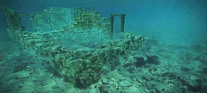
Discoveries The visible architectural remains at Pavlopetri begin some 20 m from the shore at Pounda Beach and run over 300 m south out to Pavlopetri Island. They are bounded to the east by a bedrock ridge, running north to south, and to the west by extensive sand deposits and deeper water (no remains have been identified in water depths exceeding 3 m). Beyond Pavlopetri Island and the eastern rocky ridge the sea is deeper and no artificial constructions can be traced. Nothing to indicate the existence of artificial harbour constructions or jetties could be identified in 2009. The town appears as a series of large spreads of stones indicating building complexes, amongst which a network of stone walls can be traced. The walls themselves are made of uncut aeolianite, sandstone and limestone blocks, and were built without mortar. They can survive up to three stones in height but the vast majority survive only one course high or are completely flush with the seabed. The submerged remains (buildings, streets, cist graves, and rock-cut tombs) recorded in 1968 can be clearly identified and survive more or less in the same condition as they were originally reported (though most of the cist graves seem to have been interfered with).

The existence of the eastern rocky ridge has protected the remains from the full force of wave action over the years – where there are gaps in the ridge walls have either been completely eroded away, as seems to have happened near Pavlopetri Island, or they have been eroded flush with the seabed. The accuracy of the survey plan produced in 1968 was checked and verified using the total station and sector-scan sonar. In addition to the recording of the 30,000 m2 of buildings first identified in 1968, over 9000 m² of new structures were discovered coming out of the sand to the north of the original remains in 2009. It is likely that these remains had been covered by sand deposits in previous years, as they had not been seen by divers or swimmers visiting the site in 1967, 1968, or 2008. The suggestion that the buildings were recently exposed was borne out by the cleaner appearance of the stonework in the new areas compared to the older areas which feature well-established marine algal species and encrusting marine organisms (especially brown and black sponges and sea urchins). Changes in sand cover could be related to changes in the position and shape of the shoreline over time causing variability in wave action (cf. Galili and Rosen). Equally the map of the bathymetry and topography of the town and the eastern bedrock ridge that protects the site shows there are low gaps in the ridge where wave action would pass through and be diffracted and refracted round Pavlopetri Island itself, and the other high points. This would result in a focusing of wave energy at discontinuous points over the town and the adjacent beach, with a pattern of high and low energy determined by the recent wave direction. While this shifting pattern is not yet understood, the discoveries made in 2009 suggest that revisiting the site in future years and at different seasons may reveal further parts of the Bronze Age town, which are at present under thick beds of sand.

The newly discovered remains consist of an area of at least 25 conjoined square and rectilinear rooms (built of rough square limestone blocks as elsewhere on the site) starting some 10 m from the existing shoreline. A 40 m long street was also identified lined with rectilinear buildings with stone foundations. One square building, measuring c. 3 × 3 m, contains the remains of a central pillar-like structure comparable on first glance with pillar crypt rooms associated with palaces and villas on Minoan Crete (cf. McEnroe 1982). If this room were indeed a pillar crypt it would be the first example from the Greek mainland. Two new cist graves were discovered alongside what appears to be a Bronze Age pithos burial located in a corner of one of the newly discovered rooms.

One of the most important discoveries of the 2009 season was the identification and recording of a large trapezoidal building, measuring c. 34 m in length and 12–17 m in width. The structure contains at least three separate rooms and is comparable in layout to Early Bronze Age (EBA) buildings (cf. Shaw 1987; Darcque and Treuil 1990). Its large dimensions and its prominent position within the settlement certainly imply that it was a building of some importance. The new discoveries, combined with the data from the 1968 survey, suggest that the town is increasing in size and importance. The visible remains now cover almost 4 ha and consist of intact stone building foundations, monumental structures, courtyards, streets, cist graves, and rock-cut tombs. Given that there are probably still many more buildings hidden under the sand, and that scattered fragments of walling are found out toward Pavlopetri Island suggesting that the town originally extended as a fully built-up area as far as the island, the original size of the settlement is likely to have been at least 8 ha. Given the lack of rubble from the site as a whole it is likely that the surviving walls represent the ground floor of the buildings with stone foundations built to around a metre in height and the upper sections constructed of mud brick and/or timber frames covered in plaster. Thus only the very base of the wall was stone, probably to prevent the foundations from being eroded away by rain and water running down the streets.

The ongoing study of the pottery sampled in 2009 (a total of 442 ceramic artefacts alongside an iron nail and an obsidian chip) provides the following statistical data: 3% Final Neolithic, 40% Early Bronze Age, 15% Middle Bronze Age, 25% Late Bronze Age, 3% Classical/Hellenistic, and 0.5% Roman/Byzantine. The remaining 13.5% of the pottery is provisionally characterized as ‘Bronze Age’.* The discovery of a group of sherds dates the original occupation of the site in the Final Neolithic period. The Final Neolithic pottery shows affinities with examples from contemporary settlements and cave sites in Laconia, whereas the occupation of the site during this period corresponds well with the evidence from other sites in the vicinity of Pavlopetri (Waterhouse and Hope Simpson 1961: 145–6; Gallou 2008: 294) as well as cave sites in the Vatika region (Efstathiou-Manolakou 2009: 14–15). An extensive range of EH pithoi and storage jars can be identified decorated with an impressive repertoire of rope- and finger-impressed patterns. In addition to the storage vessels (some with mat-impressed bases), the sampled pottery features the standard EBA shapes such as cups, sauceboats, conical saucers, askoi, portable hearths, and dishes. Significant for our understanding of the relations between Pavlopetri and the Aegean is the pottery that shows close links with the Cyclades, western Crete, and northeast Aegean (Henderson et al., in press).

*[NovoScriptorium: What we have here is an ancient settlement with apparent ‘cultural continuum’ from the Late Neolithic until the Late Bronze Age. And it is not the first one we find in the Greek peninsula with these characteristics. The Ancient Greek Tradition firmly speaks of ‘locality’ and evolution of the same people in the area since deep Antiquity. Quite surpisingly, the prevailing theories speak of a supposed ‘complete population replacement’ of the Neolithic inhabitants of the Greek peninsula with ‘other populations’, something which is not at all supported neither by the Ancient Tradition nor by archaeological evidence]

Although the rate of submergence in any given millennium, or the size of downward steps of subsidence, are not yet established independently, the evidence so far indicates that the Bronze Age town area was probably inundated and awash by the time of the Roman Empire, and thus completely abandoned. This is consistent with no later construction on the site, whereas other settlements in Laconia often have continuous occupation with construction of large buildings in the Roman and Byzantine periods (e.g. Asopos, modern Plitra [Flemming 1973: 10–11]).
(Source: “The Pavlopetri Underwater Archaeology Project: investigating an ancient submerged town”, by Jon C. Henderson, Chrysanthi Gallou, Nicholas C. Flemming and Elias Spondylis)

Abstract This paper presents the preliminary results of the ongoing research at the now submerged prehistoric town at Pavlopetri on the Malea peninsula in south-east Laconia. Through the assessment of the archaeological data available from the 1968 and 2009 survey seasons, this paper aims at presenting the evidence for the Early Helladic occupation of the town, reconstructing the local community’s contacts with their Laconian neighbours and beyond, and at placing the harbour town within the context of Early Bronze Age seafaring and exchange networks.

Building IX has been dated tentatively to the EBA and was assigned — albeit with caution — a ritual character. The building is exceptional in its architectural plan (elongated with small apses on both short sides), construction technique (large, unworked, single stones placed on edge, with possibly a wooden or mudbrick superstructure) and its positioning within an enclosed area. Three Early Minoan conical cups were found in between the stones of its walls.
The building is scattered with EH, Neopalatial and LH III sherds, mainly from storage and drinking vessels. Certainly, excavation will provide further information on the date and character of Building IX.

More than 60 rock-cut graves cluster around the part of the low ridge that separates the salt lake of Strongyli from the sea, just 30 to 50 m to the north/north-west of the submerged settlement; the majority were cut into the eastern side of the ridge, facing the settlement.
The graves do not follow any specific pattern of orientation, which seems to have been governed by the slope of the rocky outcrop thus facilitating the cutting of the tombs. The burial chambers are usually circular and only a few are kidney-shaped. The diameter of the circular tombs ranges from 1.20 to 1.70 m and their height would not have exceeded a meter. All graves were approached by a dromos and an entrance. The dromoi are short, about 1 m long and 0.50 m wide; they are rectangular or wedge-shaped, often with rounded corners, and are either flat or descend steeply to the floor of the grave. The steepness of the dromos was occasionally ameliorated by cutting one or two steps (c. 0.20 m high each) at the beginning. The entrances are shallow (0.07 m) but wide (0.41 m). Their height varies from 0.20 to 0.40 m. No slabs or walls blocking the entrance have survived in situ. Most of the roofs have collapsed long since. Where the roof has survived, this is either flat or roughly domed. It appears, however, that some of the graves, especially those with exceptionally low entrances, would have been hollowed out and entered from above, using a capstone to seal the grave after the burial.

The first indication of imported material at EBA Pavlopetri is provided by the occurrence of more than 20 blades and chips, and one core of obsidian from Melos.
The obsidian from the Maleatic sites is black, and in a couple of cases grey-banded, and translucent. The occurrence of this kind of obsidian is frequently attested in the Vatika region.
The Malea peninsula is ideally situated opposite Melos; at times when travel was practiced without sail, the unworked nodules would have been transported from the Melian source to the few safe landings available on the Malea peninsula. No doubt, the most accessible and most safely positioned of these landings could have served as centres for procurement, receipt and exchange of obsidian.

Cycladic, Minoan and north-eastern Aegean traits (and possible imports) in the EH ceramic repertoire from Pavlopetri speak for the involvement of the local community into the trans-Aegean exchange networks of the EBA. Harding, Cadogan and Howell even suggested that ‘the position beside the sea, the possible connections between the cemetery on the shore and Manika, and the links with Syros culture pottery suggest that the first settlers arrived by sea, perhaps from the Cyclades.’
Although there is no evidence to support this hypothesis, the maritime character of the town and its involvement in long-distance trade have been confirmed by the recent investigations. Pavlopetri participated in the regional exchange network involving Kythera and southern Laconia. Kythera, the Vatika bay and Elaphonisos create an enclosed area in which interaction and exchange would have taken place frequently. This is confirmed by the similarities shared in the ceramic repertoire from Pavlopetri and the wider Vatika region, including other EH II sites along the western Maleatic coast, in particular Bozas Asopou, Plytra Goulas and Daimonia Kastelli, and Ayios Stephanos further north, as well as with Kythera, especially Kastraki, Kastri and the sites on the northern part of the island.The ongoing research at the submerged prehistoric town at Pavlopetri indicates that it was a key harbour town with an important gateway community that was actively involved in the exchange network formed by Crete, the wider Aegean area and mainland Greece in EBA times. The forthcoming excavations at Pavlopetri hope to clarify further issues of EBA chronology and maritime connections and will continue to reveal more about the EH period in Laconia.
(Source: “Pavlopetri, an Early Bronze Age harbour town in south-east Laconia”, by Jon C. Henderson, Chrysanthi Gallou)

Abstract This paper presents a vision-based underwater mapping system, which is demonstrated in an archaeological survey of the submerged ancient town of Pavlopetri. The snorkeler or diver operated system provides a low cost alternative to the use of an AUV or ROV in shallow waters. The system produces textured three-dimensional models, which contain significantly more information than traditional archaeological survey methods. The photo-realistic maps that are produced allow further archaeological research to be performed, without diving on a site during the restrictive time limitations of permits and field seasons. The hardware and software components of the mapping system and its method of operation are described, and initial results are presented and discussed.

This paper presents a stereo-vision mapping system designed for use by a snorkeler or diver. The diver-rig contains a sensor suite similar to those found on many AUVsor ROVs, enabling low-cost production of high resolution maps in shallow waters. Textured three dimensional models are produced, which may accurately reconstruct complex structures where mosaicing methods become inaccurate. Anautomated processing pipeline allows the rapid production of maps, requiring less labour than existing archaeological surveying methods. The data processing software is based on the Simultaneous Localisation and Mapping (SLAM) framework which has been widely used to localise a robot in an unknown environment. This paper reports, to our knowledge, the first use of a stereo-vision SLAM system operated by humans to systematically document an archaeological site.

Conclusions The diver-rig and associated processing pipeline are a promising approach to documenting relatively small-scale sites in shallow waters. The data collection process, which is similar to operating a regular underwater camera, is a logistically simpler and more economical alternative to deploying an AUV or ROV system. A trade-off arises from the fact that the diver-propelled system offers substantially lower coverage than an AUV could accomplish. The involvement of experts in the data gathering process provides a level of quality control and insurance in collecting the intended data. It also provides the opportunity for ‘on the fly’ adaptive behaviour such as following walls or collecting more data over interesting areas, which would be challenging to produce reliably with a robot. While operators are required to collect data, this does not represent an additional burden to typical archaeological field programs. Preliminary results suggest the 3D reconstructions provide a representation that is suitable for archaeological interpretation. For comparable effort to the Total Station survey, the output of our approach is considerably richer, and does not require the decision at the sampling stage of which points best describe the structures in the site. The ease with with which large scale reconstructions can be visualized provided a new perspective to archaeologists that are working on the site. The ability to share these reconstructions with other experts and the general public also open up new venues for collaboration and diffusion of archaeological work.
(Source: “Reconstructing Pavlopetri: Mapping the world’s oldest submerged town using stereo-vision”, by Ian Mahon, Oscar Pizarro, Matthew Johnson-Roberson, Ariell Friedman, Stefan B. Williams and Jon C. Henderson)

Abstract Documenting underwater archaeological sites is an extremely challenging problem. Sites covering large areas are particularly daunting for traditional techniques. In this paper, we present a novel approach to this problem using both an autonomous underwater vehicle (AUV) and a diver‐controlled stereo imaging platform to document the submerged Bronze Age city at Pavlopetri, Greece. The result is a three‐dimensional (3D) reconstruction covering 26,600 m2 at a resolution of 2 mm/pixel, the largest‐scale underwater optical 3D map, at such a resolution, in the world to date. We discuss the advances necessary to achieve this result, including i) an approach to color correct large numbers of images at varying altitudes and over varying bottom types; ii) a large‐scale bundle adjustment framework that is capable of handling upward of 400,000 stereo images; and iii) a novel approach to the registration and rapid documentation of an underwater excavations area that can quickly produce maps of site change. We present visual and quantitative comparisons to the authors’ previous underwater mapping approaches.
(Source: “High‐Resolution Underwater Robotic Vision‐Based Mapping and Three‐Dimensional Reconstruction for Archaeology”, by Matthew Johnson‐Roberson, Mitch Bryson, Ariell Friedman, Oscar Pizarro, Giancarlo Troni, Paul Ozog, Jon C. Henderson)

Abstract Greece is considered to be one of the most popular worldwide tourism destinations, since it is ranked in the 15th position of the world host countries for the year 2015. Despite the industry’s dynamism, inherent weaknesses of Greek tourism products, such as seasonality, geographical distribution, saturation of popular island areas and tourist products single cultivation, are an obstacle to the areas’ sustainable development. Repositioning of Greek tourism in the international market may take place by utilizing alternative forms of thematic tourism. Scuba diving as an alternative tourism form may be a relevant and a decisive development factor and may offer the advantage of innovation by creating new tourism products. In this current study the development prospects of diving tourism through the creation of a diving center in Peloponnese’s Pavlopetri, the oldest submerged city in the world, have expanded. The prehistoric city of the Early Bronze Age can highlight the area as a new tourism destination and win the attributed share of the market. For imprinting the current situation and for developing a strategic plan, S. W. O. T. Analysis was conducted, which is considered to be a tool that analyzes the internal and external environment and reflects to the potential strengths and weaknesses of Pavlopetri as well as the opportunities and potential threats that exist in the tourism industry environment in the wider region of Peloponnese. Furthermore, interviews of the areas’ institutional and professional authorities support the opinion that there could be multiple benefits from the sustainable development of the region, through the creation of a thematic diving park, the protection of remarkable prehistoric characteristics and through the promotion of the cultural heritage. In conclusion, it is supported that as the global market continuously seeks differentiated tourism products, the Peloponnese region can become a quality tourism destination, highlighting different ways of tourism approach through scuba diving and sports recreation activities.
(Source: “Pavlopetri, the World’s Oldest Submerged City: Analysis of Dive Tourism Perspectives Development in the Region Through S. W. O. T Analysis”, by George Kipreos, Pantelis D. Konstantinakos, Ioanna Anagnostopoulou, Anastasia Perrea, Stylianos Kaprinis)

Research-Selection-Comments for NovoScriptorium: Philaretus Homerides
Related Post
The entire tomb is filled with signs and symbols that mention Queen Nefertiti and after some time passed and linguistic experts managed to decipher the stories told here, the team was baffled.
The mystery of the Solar Temple of Abu Gurab and its “Star Gate” comes to light
Thuya, the mother of Queen Tiye, left a monumental legacy by becoming the grandmother of Akhenaten and Tutankhamun.
The oldest traditions lead us to believe that blacks were the first inhabitants of Mexico.
The REAL face of King Tut: The pharaoh had feminine hips, clubfoot, and protruding teeth according to the ‘virtual autopsy,’ which also revealed that his parents were brother and sister.
The “oldest gold of humanity” was found in the Varna necropolis, on the Bulgarian Black Sea coast